“BaAn-free” research project makes obstacles visible
Accessibility in public spaces is an everyday challenge for many people. Wheelchair users in particular can be significantly restricted in their mobility by obstacles such as high kerbs or uneven paths. Although digital maps for recording such obstacles already exist, they are usually based on manual entries, which can quickly become outdated and contain errors.
This is precisely where the “BaAn-frei” research project comes in. It is investigating whether artificial intelligence can be used to automatically detect and visualise barriers in public spaces. “BaAn-frei” is funded by the Federal Ministry for Digital and Transport (BMDV). The project will run from May 2024 to October 2025 in collaboration with the Catholic University of Applied Sciences Freiburg (KHF).
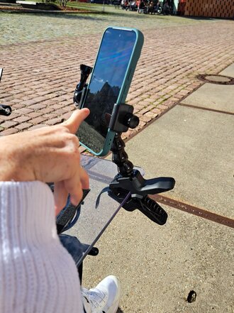
For the implementation, ordinary smartphones are attached to wheelchairs with mounts that film the ground while driving. The video recording takes place in the specially developed app, which also links the video data with corresponding GPS data. The data collected is then automatically transferred to a central server.
The evaluation takes place on the server using an AI image recognition model that has been trained to recognise typical barriers such as kerbs or cobblestones. Information such as ground conditions or kerb height is stored and mapped using GPS data. The results are then integrated into open data platforms such as OpenStreetMap to make them generally usable.
The data obtained is intended to help wheelchair users plan their everyday mobility more easily by making barriers and obstacles visible even before they start a route. This enables them to select barrier-free routes, avoid obstacles and plan routes more easily.
Contact the project team: baan-frei(at)hs-furtwangen.de
Internal link opens in the same window:More information on the project