Mobility and Participation for all

Welcome to BaAN-frei − Overcoming barriers together!

BaAN-frei is an innovative research project that uses state-of-the-art technology to make barriers in the everyday lives of wheelchair users visible.

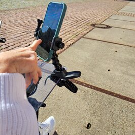
The equal participation of people with disabilities in social life is a fundamental human right. The “BaAn-Frei” project aims to identify the barriers that people who rely on a wheelchair face in everyday life. The aim is to design a tracking system and to process and analyze the data using an AI-based analysis method so that the surface characteristics of individual locations can be determined. The results of the analysis are processed digitally and made available via appropriate interfaces. People in wheelchairs will be able to digitally inspect the accessibility and condition of individual streets and locations and record them independently using simple technologies. After being passed on to the relevant local authorities, the project results serve as a basis for planning and further developing urban and rural infrastructure and can therefore contribute to increasing accessibility and inclusion in individual locations.

Problem definition

Inclusion and participation are important social values, but they are often insufficiently implemented or facilitated. Many public places and transport structures are not or only partially accessible. Wheelchair users have limited or no access to up-to-date, detailed and correct information on accessibility. As a result, people with limited mobility are severely restricted in their participation in social life.

Project goal

In order to close the existing data gaps, this feasibility study will investigate the extent to which barriers that hinder wheelchair users in everyday life can be automatically analysed and recorded. The aim is to make everyday mobility planning easier for wheelchair users. Artificial intelligence will be used to identify barriers by automatically evaluating video recordings of wheelchair users. The results are to be made publicly accessible to enable integration into digital maps and make the information available to all people with mobility impairments.

Implementation

A smartphone application is used to capture information along a route using the smartphone camera and GPS signals. This creates videos that include underground data such as roads, paths, kerb crossings, kerbs and the corresponding GPS coordinates in order to digitally localise the recorded content. The collected videos are transmitted to a research server where the data is analysed. Artificial intelligence is used for the automated analysis, which independently assigns the images to categories (e.g. kerb drops). 
This process allows potential obstacles to be automatically identified on a map using artificial intelligence without the need for manual evaluation of the data.

The BaAN-Frei project

Contact with project team

Would you like to find out more about our BaAn-Frei project? The project partners are available to help! Please send an email to:

Baan-frei(at)hs-furtwangen.de


Jump to the top of the page